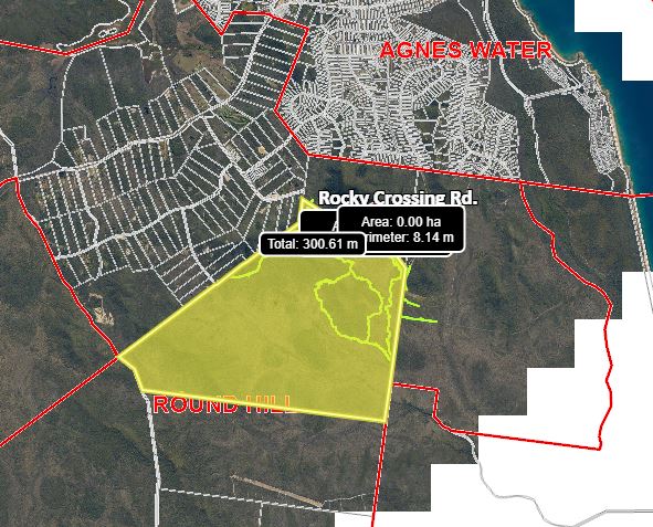
Living Here
- Pets and Animals
- Residents
- Report
- Environment
- BackEnvironment
- Air Quality
- Biodiversity
- Biosecurity
- Blue-green algae blooms
- Bushfire Mitigation
- Coasts and Coastal Vegetation
- CoastSnap
- Conservation Programs and Initiatives
- Erosion and Sediment Control
- Feral Animals
- First Nations Fire and Land Officer
- Landfill Gas Abatement
- Mosquitoes
- Pests and Weeds
- Weed Spray Equipment Hire
- Wildlife
- Community Development
- Community Investment
- Services
- Emergencies
-
Benaraby Landfill - Fire Water Tanks Installation
- Location
- Benaraby Landfill, 48567 Bruce Highway, Benaraby
- Description of Works
-
This project is included in Council’s 2024/25 Capital Works program and will involve installation of water storage tanks for on-site firefighting when/if required at Council’s Benaraby Landfill site.
Works will include civil and earthworks, road and ancillary works, retaining wall construction, tanks, access and piping installation. - Commencing
- 6 August 2024
- Completion
- 14 Mar 2025
- More information
-
A wildfire event in 2020 impacted Benaraby Landfill and a site assessment was undertaken to provide recommendations for bushfire mitigation action.
Risks were identified with no standpipe on-site and with mains water trickle feed to the landfill.
During the wildfire event emergency service vehicles had to travel to Benaraby to refill during the wildfire.
This project will install two fire water tanks on-site to meet legislative requirements and provide a source of water for emergency services during a wildfire event.
This will assist with response time during fire emergencies, reducing potential risk to the facility and community.
If visiting Benaraby Landfill you may notice increased work activity occurring. Please be mindful of works occurring and follow any signs or directions.
-
Benaraby Landfill - Piggyback Liner System Installation
- Location
- Benaraby Landfill, 48567 Bruce Highway, Benaraby
- Description of Works
-
This project is included in Council’s 2024/25 Capital Works program and is aimed to maximise current landfill airspace capacity.
Works will include relocation of landfill gas infrastructure, civil and earthworks and the installation of a geomembrane liner.
The piggyback liner system will ensure Council meets environmental and legislative requirements, and will enable maximum utilisation of Cell 3a by extending cell airspace. - Commencing
- 3 February 2025
- Completion
- 30 June 2025
- More information
-
The Benaraby Landfill site, activated in 1989 to cater for waste disposal in our region, has been master-planned to facilitate 12 cells.
Cell 1 and Cell 2 are filled and closed, Cell 3a constructed in 2021, is filling fast and approaching the end of its expected five-year life-span.
Capacity forecasts in mid-December 2024 indicated Cell 3a is 45 per cent full. Considering our region’s waste disposal data, Cell 3a is predicted to reach capacity by June 2027.
Cell 3a was designed to be filled to the height of the adjoining Cell 1. A piggyback liner system now needs to be installed between the two cells to prevent potential contamination of ground water and soil and to ensure leachate from waste is captured in the Cell 3a leachate management system.
What to expect
If visiting, or passing by Benaraby Landfill, you may notice increased work activity occurring.
Please be mindful of works occurring, of increased traffic through entry gates and on roads within the facility and follow any signs or directions.
Parks scheduled works
Regular maintenance and operational development of Gladstone Region parks, reserves, open spaces and playgrounds is conducted by Council staff throughout the year including all furniture, play equipment, structures and trails.
Information and updates are posted on our Facebook page.
For more information, please contact Council on (07) 4970 0700.
-
Agnes Water Skate Park Revitalisation
- Location
- Springs Road, Agnes Water
- Description of Works
-
Funded under Round 1 of the Australian Government’s Growing Regions Program, the $1.94M Agnes Water Skate Park Revitalisation project is progressing with the next steps to involve site investigation works and detailed design phase.
The detailed design for the project is based on the concept design which was endorsed by Council and developed through extensive consultation with the community and stakeholders.
Construction commencement will be dependent on completion of the detailed design and receival of any required statutory government approvals.
At this stage, the timeline for construction is anticipated to commence during the 2025/26 financial year.
- Commencing
- Thursday 9 January 2025, Site Investigation and Detailed Design phase
- Completion
- 17 November 2025, Site Investigation and Detailed Design phase
- More information
-
Once complete, Agnes Water will have a fit for purpose skate facility that is safe, modern and suits a range of skill levels for skateboards, BMX and scooters.
More updates on this exciting upgrade will be shared when the project moves closer to construction.
The $1.94M Agnes Water Skate Park Revitalisation project has been jointly funded by the Australian Government’s Growing Regions Program - Round 1 and Gladstone Regional Council.
Project dates mentioned are a guide only. Due to the nature of construction projects and unforeseen delays, works and timeframes may vary.
* To enable our teams to focus on project progression, for project queries please contact Council on 4970 0700.
-
Bulburin National Park - Range View Camp and Dawes Range road temporarily closed
- Location
- Bulburin National Park
- Description of Works
- Range View campground and Dawes Range road is temporarily closed due to the road being unsuitable to drive.
- Commencing
- 19 December 2024
- Completion
- 4 March 2025
- More information
-
As a result, the following campgrounds are temporarily closed until further notice:
- Range view camping area
- Dawes Range road
- 4WD Loop road
All permits for closed areas are suspended for the duration of the closure. Commercial tour operators and other permit or agreement holders are not permitted to enter closed areas.Zamia and Old Forestry camping areas are currently open. These can be accessed via Bulburin Forest road.
Please monitor park alerts on the department's website for updated information.
Please observe all signage, barriers and directions from rangers and do not enter closed areas.
-
Calliope District Golf Club Irrigation Upgrade and Soil
- Location
- Calliope District Golf Club, Stowe Road, Calliope
- Description of Works
-
Calliope District Golf Club Irrigation Upgrade and Soil Remediation work is scheduled as part of Gladstone Regional Council’s Capital Works program.
This project will be delivered in stages and involves supply, installation and commissioning of a new irrigation system for the existing eighteen (18) hole course, driving range, bowling green and turf nursery.
Work also includes associated soil remediation works to resolve issues and optimise the irrigation system’s performance. This will include, but is not limited to the improvement in drainage, soil condition and re-turfing of areas on the golf club. - Commencing
- 4 May 2024
- Completion
- 27 June 2025
- More information
-
Work will be scheduled, where practical, to allow patrons to continue using the facility, however at times, access restrictions to specific areas of the golf course will apply. If on-site, please be safety conscious and follow signage and directions.
The project will involve upgrade of the Calliope District Golf Club irrigation system and soil remediation, while maintaining access for golf members to about 15 holes while work proceeds.
During these works, overall water supply to the Calliope District Golf Club irrigation systems will be maintained until the new irrigation system becomes operational.
Planned works - key dates
This extensive project is planned to be delivered in 11 stages through until about May 2025.Works forecast, weather permitting:
Project works have been slowed by wet weather with time during delays used to prepare for when the course dries and works can recommence.
Planned work, weather permitting
Work has progressed through Stages 6 & 7 and has now commenced on Stages 8 & 9:
- Stage 8
- Hole 8 - Jan-Feb
- Additional drainage to be installed across the front of the tee and the rear of the 7th Hole
- Hole 9 - Feb-April
- Will remain open until early March (until 8th Hole is re-opened)
- Hole 8 - Jan-Feb
- Stage 9
- Hole 13 - Jan-March
- Completion of swale and soil remediation
- Bunker drainage works
- Hole 14 - Feb-April
- Main and lateral irrigation lines installed
- Soil remediation and swale drain works
- Hole 13 - Jan-March
What To Expect- Works will occur six days/week from 6am-6pm Monday to Friday and from 6am-3pm on Saturdays.
- Adjustable works program to maximise patrons use of the facility.
- Some vibration, dust and machinery noise associated with work.
- At times, access restrictions to specific areas.
- Please observe signage and directions during works.
Please use this information as a guide only. Works are subject to weather and on-site conditions. Due to the nature of construction projects and unforeseen delays, works and timeframes may vary.
- Stage 8
-
Curtis Island National Park, Conservation Park, and State Forest - Feral Animal Control
- Location
- Curtis Island National Park and Conservation Park, Curtis Island State Forest
- Description of Works
- The Queensland Parks and Wildlife Service (QPWS) are planning to conduct a Feral Animal Control program utilising ground shooting to target feral pigs on Curtis Island National Park, Curtis Island Conservation Park and Curtis Island State Forest.
- Commencing
- Monday 10 March 2025
- Completion
- Friday 14 March 2025
- More information
-
are planning to conduct a Feral Animal Control program utilising ground shooting to target feral pigs on Curtis Island National Park, Curtis Island Conservation Park and Curtis Island State Forest
For more information, please call Gladstone QPWS office on (07) 49716548 or send us an email at
Please observe all signage, barriers and directions from rangers and do not enter closed areas.
Please monitor park alerts on the department's website for updated information.
This alert applies to the following parks:
- Curtis Island National Park and Conservation Park
- Curtis Island State Forest
-
Eurimbula and Deepwater National Park - Feral Animal Management - 29 Nov to 28 Feb 2025
- Location
- Eurimbula and Deepwater National Park
- Description of Works
- In conjunction with the nesting and hatching season for marine turtles as well as the arrival of migratory shorebirds, contractors and QPWS staff will be undertaking controlled trapping of the feral fox and pig population within Eurimbula and Deepwater National Park.
- Commencing
- 29 November 2024
- Completion
- 28 February 2025
- More information
-
This work will be carried out for the duration of the nesting period.
Please observe all signage, barriers and directions from rangers and do not enter closed areas.
Please monitor park alerts on the department's website for updated information.
This alert applies to the following parks:
-
Reedy Creek Paperbark Forest Walk - Temporary closure
- Location
- Reedy Creek Reserver, Agnes Water
- Description of Works
- Bush Heritage Australia has temporarily closed the Paperbark Forest Walk will be closed to public access from Friday, November 24 until further notice.
- Commencing
- Friday, 24 November 2023
- More information
-
Bush Heritage Australia are working on solutions around parking issues and the impacts visitation has on this fragile environment.
-
Turtleway Bridges - Replacement
- Location
- Stirling Park, Boyne Island and Canoe Point, Tannum Sands
- Description of Works
-
Work is scheduled for replacement of two Turtleway pedestrian bridges as part of our Capital Works program.
Removal of the existing structures and installation of new Turtleway footbridges will reduce ongoing maintenance costs and improve longevity of these valuable community assets. - Commencing
- Monday 10 February 2025
- Completion
- 30 June 2025
- More information
-
To keep our community safe, full closure of these footbridges will be needed with no pedestrian bridge access from Monday 10 February 2025 until about the end of June 2025. Pedestrian detours will be required around the work areas.
For cost savings and work efficiencies, the two Turtleway pedestrian bridges will be closed at the same time.
Works will be scheduled consecutively for bridge removal and replacement at the various sites with community and worker safety a priority.
Replacement of these footbridges will involve installation of new structures to provide improved community connectivity for years to come.
Council looks forward to delivering these asset improvement works and appreciates the patience and understanding of the community while these necessary pedestrian bridge replacements are undertaken.
Planned works forecast, weather permitting
From Mon 10 Feb: Overall works are expected to be completed by the end of June.
- From Mon 10 Feb: Stirling Park, Boyne Island footbridge work starts
- Mon 3 Mar: Canoe Point, Tannum Sands footbridge work starts
Work at both footbridges will involve:
- Mobilisation to site
- Create new access to site
- Removal of existing bridge, abutments and footings
- Site survey existing bridge line
- Installation of screw piles with concrete caps
- Survey footings and abutments
- Installation of new abutments with footing inspection
- Concrete curing time
- Bridge installation
- Demobilisation from site
A specialised piling subcontractor will be on-site:
- Thursday 6 March to Friday 14 March: Stirling Park footbridge
- Monday 24 March to Tuesday 1 April: Canoe Point footbridge
- The piling subcontractor will install the precast concrete bridge piles.
- Extensive noise and vibration will be associated with the works.
- Work will occur from 6.30am-5.30pm Monday to Friday and between 6.30am-4.30pm on Saturdays.
- There is a high probability that while the piling contractor is on-site that works will occur on a Sunday at each location.
What to expect
Please be mindful of construction works occurring:
- Noise and vibration from the work area is expected.
- Temporary fencing installed.
- Heavy machinery operating.
- Please follow directions and signage in the area.
- Pedestrian detour in place for the Stirling Park footbridge.
- Pedestrians are required to plan an alternative route to avoid the works area near the Canoe Point footbridge.
The Turtleway Bridges Replacement project is proudly funded by the Federal Government’s Local Roads and Community Infrastructure (LRCI) Program - Phase 4.
-
Vehicle access restrictions, Joey Lees beach, Curtis Island
- Location
- Curtis Island National Park and Conservation Park
- Description of Works
-
Vehicle access to the Joey Lees beach and lower sections of the headland is no longer permitted.
This closure is necessary to enable rehabilitation of eroded sections of the Joey Lees headland to protect the natural values of the coastal headland communities. - Commencing
- 1 June 2024
- Completion
- 31 May 2025
- More information
-
It is hoped that through the completion of the rehabilitation works the natural integrity of the headland will be reinstated and continue to enhance natural visitor experiences.
A new three-bay car park has been provided on the top of the headland for day visitors. Existing pedestrian access to the beach and lower sections of the headland are maintained.
Please monitor park alerts on the department's website for updated information.
This alert applies to the following park:
-
No planned burns to report.
- More information
# | Name | Size |
---|
Archived public notices
# | Name | Size |
---|
# | Name | Size |
---|
# | Name | Size |
---|
# | Name | Size |
---|
# | Name | Size |
---|
# | Name | Size |
---|
Roadworks, conditions and closures
Refer to the RegionWatch website for up to date road conditions and scheduled works. Information and updates are posted on our Facebook page for short term and unscheduled works.
Regular maintenance and operational development of Gladstone Region roads are conducted by Council staff throughout the year.
For more information, please contact Council on (07) 4970 0700.
-
Refer to RegionWatch for current road conditions
-
Donohue Dr, Agnes Water - New Footpath
- Location
- Donohue Drive to Skate Park on Springs Road, Agnes Water
- Description of Works
-
The link between Donohue Drive and Springs Road has been identified as a valuable connection for the community.
A dirt track has linked these two roads to the nearby Skate Park community facility but its condition has deteriorated, limiting accessibility for members of the community.
Work to construct a 2m wide concrete footpath started in late January and is expected to be completed by late March, weather and site conditions permitting.
This project supports Council’s Pedestrian and Cycle Strategy, providing cyclists and pedestrians with a safe and dedicated pathway, reducing the need to share the roadway with motorists.
- Commencing
- Late January 2025
- Completion
- Monday 31 March 2025
-
The new footpath will connect Donohue Drive to the Community Facility (Skate Park) on Springs Road. This new footpath will link to the existing paths on all three sides and include kerb ramps to ensure safe access for cyclists and wheelchair users.
During construction, the road shoulder on Donohue Drive, in front of the Agnes Water State School, and the dirt track linking Donohue Drive and Springs Road will be fenced off for public safety.
Efforts will be made to minimise disruptions during peak school hour drop-off and pick-up times.
What to expect
- Works Mon-Fri, 6am to 6pm.
- Heavy machinery operating.
- At times, traffic delays.
- If in the area, please follow signs and directions.
-
Lowmead Road - Upgrade Work
- Location
- Staged works along Lowmead Road from the Fingerboard Rd-Lowmead Rd intersection to the town of Lowmead
- Description of Works
-
The Lowmead Road Safety and Sealing Upgrade project consists of four stages of road upgrades forecast to be completed on Lowmead Road during this financial year and the next.
Sections of road will be upgraded from the Fingerboard Road-Lowmead Road intersection to the town of Lowmead.
This project will provide an improved, more resilient road with alignment adjustments to offer increased safety for motorists and improved road resilience during wet weather. - Commencing
- 7 August 2023
- Completion
- Financial year 2024/25
-
What’s been happening?
- Granite Creek Bridge
- Local road users will have noticed the commencement of bridge construction works in Granite Creek. Works are anticipated to continue through to mid-2025, including minor road adjustments to align road approaches with the new bridge, once complete. The community is advised that no access to the construction site is permitted and local road users only may continue to drive across Granite Creek using the existing causeway.
- Stages 2, 3 and 4 of Lowmead Road
- Local road users will have noticed approximately 2000m of sealing works completed in Stage #3, in a stretch of road between Colosseum Creek and Granite Creek.
Planned works, site conditions and weather permitting:
- Stage #2
- Stage #2 is approximately a 7km of section of road that commences at Colosseum Creek crossing and continues towards Lowmead. Construction works commenced in August 2024 and are anticipated to continue until about Easter 2025.
- Stage #3, Stage #4
- Council has a Contractor team working on these sections of road, which are separated by Granite Creek. The Contractor team is also completing the Granite Creek Bridge works. Works in these areas are expected through to mid-2025.
- Road conditions to expect until mid-2025
- Suburb: Lowmead Road to Mount Tom
- Street: Lowmead Road from Clarkes Road to Fingerboard Road
- What’s happening:
- Road works. Closed. Local traffic only.
- Detour for non-local traffic via Gorge Road, Lowmead Road or Tablelands Road, Berajondo.
- Expect delays. Follow signs and directions.
More information
- All forecast works in 2025 will occur either on or directly adjacent to the existing road. Traffic controls will be in place, so please observe directions and reduced speed zones at all times.
- Local road users should anticipate significant site activity from January to June 2025 while multiple crews (both Council and Contractors) will be working simultaneously across Stages 2, 3 and 4 and the Granite Creek Bridge site.
- Noise, dust, construction traffic and heavy machinery is expected in the area.
The Lowmead Road Safety and Sealing Upgrade project is being delivered by Council and its Contractors in 2024 and is included in Council’s Capital Works program. This project has secured the support of the Federal Government to widen and seal more than 20km of Lowmead Road in 2024 via the Remote Roads Upgrade Pilot Program (RRUPP). The Granite Creek Bridge project has secured funding from Disaster Recovery Funding Arrangements (DRFA), which joins Commonwealth and State government funding to help communities recover from disasters.
- Granite Creek Bridge
-
Turkey Beach Road Upgrades
- Location
- Turkey Beach Road, Turkey Beach
- Description of Works
-
Road realignment upgrade and safety improvement works including road widening and road resealing.
Works Area #1 - Between Dyckhoffs Road and Scrubby Creek
Works Area #2 - Between Scrubby Creek and Sandy Creek
During construction works please plan for possible delays, speed reductions and traffic control measures.
Traffic reduced to single lane, as required.
Motorists are urged to drive carefully through the works area and adhere to any reduced speed limits, changed traffic conditions or directions. - Commencing
- Late May 2024
- Completion
- Mid 2025
-
Turkey Beach Road Safety Improvement works are proudly funded by the Queensland Government through the Transport Infrastructure Development Scheme (TIDS) and Gladstone Regional Council.
-
Jeffery Court - Road Safety Improvements
- Location
- Jeffery Court, Agnes Water
- Description of Works
-
Council is undertaking road safety improvement work along a section of Jeffery Court adjacent to Tom Jeffery Memorial Park, Agnes Water.
Following community feedback and review of this busy traffic area, consideration has been given to public safety, speed limit and improvements to traffic flow to increase safety for our community and visitors to the region.
Work will be completed in stages as part of Council’s 2024/25 Capital Works program to complement later construction of the nearby Agnes Water Beach Visitor Carpark. - Commencing
- 21 October 2024 (Stage 1), Recommencing 10 February 2025 (Remaining Stage 1 work and progression to Stage 2)
- Completion
- 31 March 2024 (Majority of Stage 1 roadwork), Stage 2 work completion date, to be advised
-
Project update
- Work is planned to restart on site from 10 February 2025.
- Majority of Stage 1 roadworks are complete with a portion of remaining works to be delivered early in 2025.
Work is scheduled, site conditions and weather permitting, along the northern side of Jeffery Court (on the road and embankment near the boundary of NRMA Agnes Water Holiday Park and Tom Jeffery Memorial Park):
- Stage 1 - Drainage, road widening, new kerb, asphalt reseal, line-marking and road sign installation within the work area. Installation of mountable kerbing.
- Stage 2 - Construction of retaining wall and boardwalk on embankment adjacent to Tom Jeffery Memorial Park.
More information
To make it safer for drivers, pedestrians, community and visitors to the park and beach, when complete, works along this section of Jeffery Court will introduce:
- Reverse angle parking: 18 parking bays to replace existing parallel parking bays, utilising available space and providing greater off-road safety during vehicle unpacking/loading.
- Lower speed limit: a 10km/hr shared zone will apply.
- No queue signage: traffic will not be permitted to queue on the road.
- Existing one-way traffic flow to remain: current one-way flow of traffic conditions will continue.
- Retaining wall and boardwalk: Work in 2025 to provide a safe pedestrian path to connect to existing pathways.
What to expect during works
During works, you’ll notice workers and activity in the work area with some brief traffic disruption and partial road closure required at times.- Works - Monday to Friday, 7am-5pm, site conditions and weather permitting.
- Traffic management.
- At times, dust and machinery/equipment noise can be expected from the project site.
- Some local traffic only restrictions under traffic control.
- Reduced speed limit.
- At times, partial road closure and road changes.
- Please follow signs and directions.
-
Asphalt Resurfacing - Gladstone
- Location
- Stage 1 - Sections of J Hickey Avenue, Tinaroo Court, Fairbairn Place
- Description of Works
-
Stage 1 of our resurfacing program, scheduled as part of Council’s 2024/25 Capital Works program, includes pavement repairs and asphalt renewals along about 2.7km of J Hickey Avenue, in addition to side streets Tinaroo
Court and Fairbairn Place, delivering over 43,520m2 of new road surfacing and line marking for the community.
Removing defects in the roadway and overlaying the road with a new asphalt surface will extend their life and provide a smoother driving surface. - Commencing
- Monday, 24 February (Stage 1)
- Completion
- Friday, 11 April 2025 (Stage 1)
-
More information
To minimise traffic disruptions, works near St John’s Primary School, on J Hickey Av (between Gretel Dr and Aramac Dr), are planned to occur in April during the school holidays and before the Easter public holidays.
The Contractor will letterbox drop properties within the works area prior to works.Stage 1 - Planned Works, weather permitting
24 to 28 Feb:
- J Hickey Av (Col Brown Av to Aramac Dr),
- Tinaroo Court,
- Fairbairn Close.
6-13 Mar: J Hickey Av (Aramac Dr to Alexandra Cl)
7-11 Apr: J Hickey Av (Mcginlay St to Gretel Dr)
Above dates are a guide only. Due to the nature of construction projects and unforeseen delays, works may vary.
What to expect
- Works generally carried out from Mon-Fri, 6am-6pm.
- Residents asked to park their vehicles off the road when works are planned in their street.
- Noise, dust and vibration may be generated from construction activities.
- At times, some traffic delays and some restricted access to streets.
- Traffic management in place.
- Access to properties maintained.
- Contractors to help direct drivers entering/exiting properties.
- Please drive carefully through work areas and adhere to any changed road conditions and reduced 40km/h speed limits.
Overall road resurfacing works in Gladstone are included in Council’s annual road renewal budget.
J Hickey Avenue asphalt resurfacing works are proudly supported by the Australian Government’s Local Roads and Community Infrastructure (LRCI) Program - Phase 4.
Water & Sewer interruptions
Refer to the RegionWatch website for up to date interruptions and scheduled works.
Regular maintenance and operational development of Gladstone Region water and sewer networks are conducted by Council staff throughout the year.
For more information, please contact Council on (07) 4970 0700.
After water is turned on:
- On resumption of the water supply a hot water tap should be turned on to flush any air pockets from the pipes, then turn the hot water heater on again.
- We advise that you check the water prior to use. If it appears discoloured we suggest you turn on the nearest external tap to the meter and let it run for a period of time, or until it runs clear, and then do the same to the furthest external tap from the meter, to clear your pipework.
- Please do not wash clothes at this time to prevent staining from any discoloured water.
Council apologises for any inconvenience this interruption may cause. For more information contact us online or call on (07) 4970 0700.
-
Unplanned Maintenance - Agnes Water Waste Water Treatment Plant
- Location
- Agnes Water
- Description of Works
- Due to maintenance work at the Trade Waste/Septage receival station at Agnes Water WWTP. All liquid waste disposal at this location is directed to Gladstone Waste Water Treatment Plant, 17 Albert Road, Callemondah.
- Commencing
- Friday 26 July, 2024
-
Sewer Manhole Renewal - Gladstone
- Location
- Various locations in Gladstone
- Description of Works
-
Included in Council’s 2023/24 Capital Works program, Sewer Manhole Renewal work is being delivered in stages across Gladstone and involves rehabilitation works to improve reliability of the sewer network, reduce ongoing maintenance costs and meet wastewater sustainability objectives.
Machinery operation, vehicle movements, lighting, odour and noise can be associated with this work. - Commencing
- December 2023
- Completion
- June 2025
- More information
-
The Gladstone Sewer Manhole Renewal project is proudly funded by the Queensland Government’s Works for Queensland funding 2021-24 in association with Gladstone Regional Council.
-
Seventeen Seventy Sewer Rising Main Replacement
- Location
- Captain Cook Drive, Seventeen Seventy
- Description of Works
-
Works to relocate and replace 1000m of existing sewer rising main along the coastline adjacent to Captain Cook Drive at Seventeen Seventy will occur from early December 2024 to June 2025, site conditions and weather permitting.
Works will start near Endeavour Park and finish near the Seventeen Seventy boat ramp.
New alignment of the sewer rising main will prevent risks of uncontrolled sewer release to the immediate environment, supporting objectives of Council’s Our Coast Our Future Coastal Hazard Adaption Strategy to ensure appropriate adaptation responses to help avoid, mitigate, and manage the risk of coastal hazards.
This project is included in Council’s Capital Works program. - Commencing
- Late November 2024
- Completion
- June 2025
- More information
-
Work will generally involve:
- Removal and/or grouting capping of existing redundant sewer rising main (located within the foreshore area),
- Installation of new sewer rising main within the road reserve,
- New sewer rising main connection to the existing network,
- Testing and commissioning of the new sewer rising main.
Planned works forecast, site conditions and weather permitting
- Late Feb to early Mar: Captain Cook Drive, starting at Air Sea Rescue Park and finishing about 150m from boat ramp
- Feb to June: Pump station works and Captain Cook Drive road rectification
Saturday Works: Saturday 1 March to Saturday 29 March, from 7am to 3pm
- Council’s Contractor will commence Saturday works on the project to continue civil works and ensure good progress is made to complete installation of the Sewer Rising main within the scheduled timeframe for works.
- During construction works, there will be on-site traffic control in line with the existing single lane traffic used in other stages of the project.
- Throughout the day, there may be periods of disruption for residents accessing or exiting their properties, as well as for traffic along Captain Cook Drive, however this will be minimised.
Please use this information as a guide only. Due to the nature of construction projects and unforeseen delays, works may vary.
What to expect
Work is being planned in stages with public safety as a priority and with consideration of peak holiday times, the community and visitors to our region.
When works are underway in 2025:
- Contractors in the area on weekdays with at times, work at night and on weekends.
- Equipment and machinery operating with noise and dust likely from the project area.
- At times, some pedestrian detours, disruption to traffic flow, single lane alternating traffic and parking restrictions within the work area.
- At times, some amenities near the immediate work area will be closed for public safety.
- Please follow signs and directions and plan for road and pedestrian changes near the works area.
The Seventeen Seventy Sewer Rising Main Replacement project is funded by the Queensland Government’s QCoast2100 program and Gladstone Regional Council.
-
Tannum Sands Sewer Rising Main Replacement
- Location
- Millennium Esplanade, Tannum Sands from the northern end to just south of the Surf Lifesaving Club
- Description of Works
-
Works to upgrade the sewer rising main are anticipated to start in late January 2025, site conditions and weather permitting.
The existing 370m long sewer rising main pipeline, constructed in 1976, is located along the eastern side of Millennium Esplanade, Tannum Sands.
This asset has been condition assessed and identified as being at the end of its service-life and needing replacement. This project is included in Council’s 2024/25 Capital Works program with work to be carried out by a Contractor.
- Commencing
- Late January 2025
- Completion
- June 2025
- More information
-
Work will involve:
- Removal and/or grouting of existing redundant sewer rising main (located under road and footpaths in some areas),
- Installation of new sewer rising main,
- New sewer rising main connection to the existing network,
- Testing and commissioning of the new sewer rising main.
Work is being planned with public safety as a priority, with Council extremely mindful of peak holiday times in Tannum Sands with the community, visitors to our region and dates of known community events on Millennium Esplanade considered.
When works start you can expect to see Contractors in the area on weekdays with some work at night and on weekends.
Due to equipment and machinery operating in the area, noise and dust are likely from the project area.
A temporary on-site work area will be established at the northern end of Millennium Esplanade.
The sewer rising main construction involves open trench excavation using temporary fencing and metal plates to protect exposed areas outside of work hours.
At times, some pedestrian detours, disruption to traffic flow, and parking restrictions will be experienced along the esplanade.
Work is planned to occur in stages to help minimise public disruptions.
To keep the public safe, there may be times when some amenities near the immediate work area may also need to be closed.
-
Advanced Water Meters - Stage 3 Installation
- Location
- Clinton, Calliope, Mount Larcom and parts of Kirkwood
- Description of Works
-
Upgrade of existing water meter infrastructure to new, advanced water meter infrastructure at residential and commercial properties in Clinton, Calliope, Mount Larcom and parts of Kirkwood.
These works are Stage 3 of a whole-of-region, multi-year Capital Works project to upgrade existing water meter infrastructure to new, advanced water meter infrastructure. - Commencing
- February 2025
- Completion
- 30 June 2025
- More information
-
The installation of advanced water meters and access to associated technology will provide significant benefits to residential households and businesses by:
- Enabling early detection of leaks.
- Providing data and information online so the user can review and manage their water usage.
- Enabling Council officers to respond more effectively to usage enquiries regarding connections.
Every property in Clinton, Calliope, Mount Larcom and some properties within Kirkwood with an existing water meter will have upgraded infrastructure installed between February and June 2025, between 7am and 5pm Monday to Friday, with weekend work (involving later start times) approved by Council.
The age of a property’s existing water meter will determine if it is fully replaced as part of the upgrade, or if the existing asset can be retained and an advanced water meter infrastructure sensor added. There is no cost to property owners associated with this upgrade.
What to expect during works
- Council Contractors, Taggle Systems, will carry identification with them.
- Water meter upgrade takes about 15 minutes depending on the complexity of your meter.
- A vacuum truck may be required at some sites. If this is the case, please expect some noise.
- Water will be disconnected during works, stopping water flow for the installation period.
- If water is flowing through the meter and we are unable to make contact, we will come back at a later stage.
- A calling card will be left in your letterbox/on your property to advise if the installation was complete or if you need to contact Council to arrange a time for installation completion.
If you have animals or locked gates and need to be present at the install, or if you have any questions about this project, please contact Council on 4970 0700 or visit your local Council office at Mount Larcom, Calliope or Gladstone.
Following installation, residents can sign up to the My Water portal which will show near real-time water usage. Users can set up high usage alerts and receive monthly water usage reports by email.
Living Here
- Pets and Animals
- Residents
- Report
- Environment
- BackEnvironment
- Air Quality
- Biodiversity
- Biosecurity
- Blue-green algae blooms
- Bushfire Mitigation
- Coasts and Coastal Vegetation
- CoastSnap
- Conservation Programs and Initiatives
- Erosion and Sediment Control
- Feral Animals
- First Nations Fire and Land Officer
- Landfill Gas Abatement
- Mosquitoes
- Pests and Weeds
- Weed Spray Equipment Hire
- Wildlife
- Community Development
- Community Investment
- Services
- Emergencies
Latest CONNECT News out now
More Information
The cookbook is a collaborative effort between Gladstone Regional Council and Gladstone Region Neighbourhood Centre, proudly presented as part of Welcoming Week celebrations.
Download the cookbookGladstone Regional Council
Connect. Innovate. Diversify.
Get in Touch
Phone
(07) 4970 0700
Opening Hours
8.30am - 5pm Monday to Friday
Social media
Postal Address
PO Box 29, Gladstone Qld 4680
Council Offices
101 Goondoon Street, Gladstone Qld 4680
3 Don Cameron Drive, Calliope Qld 4680
41 Blomfield Street, Miriam Vale Qld 4677
Cnr Wyndham & Hayes Avenues, Boyne Island Qld 4680
Rural Transaction Centres
71 Springs Road, Agnes Water Qld 4677
47 Raglan Street, Mount Larcom Qld 4695
Footer Acknowledgement
Gladstone Regional Council would like to acknowledge the Bailai, the Gurang, the Gooreng Gooreng and the Taribelang Bunda people who are the traditional custodians of this land. Gladstone Regional Council would also like to pay respect to Elders both past, present and emerging, and extend that respect to other Aboriginal and Torres Strait Islander people. Learn more about Council's Reconciliation Action Plan (RAP).
Chat Popup
All content © Gladstone Regional Council. All Rights Reserved.
Back to the top