Living Here
- Pets and Animals
- Residents
- Report
- Environment
- BackEnvironment
- Air Quality
- Biodiversity
- Biosecurity
- Blue-green algae blooms
- Bushfire Mitigation
- Coasts and Coastal Vegetation
- CoastSnap
- Conservation Programs and Initiatives
- Erosion and Sediment Control
- Feral Animals
- First Nations Fire and Land Officer
- Landfill Gas Abatement
- Mosquitoes
- Pests and Weeds
- Weed Spray Equipment Hire
- Wildlife
- Community Development
- Community Investment
- Services
- Emergencies
-
Benaraby Landfill - Piggyback Liner System Installation
- Location
- Benaraby Landfill, 48567 Bruce Highway, Benaraby
- Description of Works
-
This project is included in Council’s 2024/25 Capital Works program and is aimed to maximise current landfill airspace capacity.
Works will include relocation of landfill gas infrastructure, civil and earthworks and the installation of a geomembrane liner.
The piggyback liner system will ensure Council meets environmental and legislative requirements, and will enable maximum utilisation of Cell 3a by extending cell airspace. - Commencing
- 3 February 2025
- Completion
- 31 July 2025
- More information
-
The Benaraby Landfill site, activated in 1989 to cater for waste disposal in our region, has been master-planned to facilitate 12 cells.
Cell 1 and Cell 2 are filled and closed, Cell 3a constructed in 2021, is filling fast and approaching the end of its expected five-year life-span.
Capacity forecasts in mid-December 2024 indicated Cell 3a is 45 per cent full. Considering our region’s waste disposal data, Cell 3a is predicted to reach capacity by June 2027.
Cell 3a was designed to be filled to the height of the adjoining Cell 1. A piggyback liner system now needs to be installed between the two cells to prevent potential contamination of ground water and soil and to ensure leachate from waste is captured in the Cell 3a leachate management system.
What to expect
If visiting, or passing by Benaraby Landfill, you may notice increased work activity occurring.
Please be mindful of works occurring, of increased traffic through entry gates and on roads within the facility and follow any signs or directions.
-
Gladstone City Library - Concrete Remediation Works
- Location
- Gladstone City Library, 39 Goondoon Street, Gladstone
- Description of Works
-
Concrete remediation works will be undertaken by contractors at the Gladstone City Library.
Works will primarily be in and around the lower-level carpark.
The project will occur in four stages with construction work in one area at a time to leave the remaining carpark open to the public. - Commencing
- 25 March 2025
- Completion
- 4 July 2025 (subject to weather and site conditions)
- More information
-
Barricades will be installed in the work area with pedestrian detours in place.
Access to the stairs, lift and disabled parking will remain open during works.
What to expect:
- Noise from machinery operating
- Changes to pedestrian and carpark access
If in the area, please be mindful of works occurring and follow any signs or directions.
We appreciate the community’s patience and understanding whilst the maintenance is carried out.
Parks scheduled works
Regular maintenance and operational development of Gladstone Region parks, reserves, open spaces and playgrounds is conducted by Council staff throughout the year including all furniture, play equipment, structures and trails.
Information and updates are posted on our Facebook page.
For more information, please contact Council on (07) 4970 0700.
-
Agnes Water Skate Park Revitalisation
- Location
- Springs Road, Agnes Water
- Description of Works
-
Funded under Round 1 of the Australian Government’s Growing Regions Program, the $1.94M Agnes Water Skate Park Revitalisation project is progressing with the next steps to involve site investigation works and detailed design phase.
The detailed design for the project is based on the concept design which was endorsed by Council and developed through extensive consultation with the community and stakeholders.
Construction commencement will be dependent on completion of the detailed design and receival of any required statutory government approvals.
At this stage, the timeline for construction is anticipated to commence during the 2025/26 financial year.
- Commencing
- Thursday 9 January 2025, Site Investigation and Detailed Design phase
- Completion
- 17 November 2025, Site Investigation and Detailed Design phase
- More information
-
Once complete, Agnes Water will have a fit for purpose skate facility that is safe, modern and suits a range of skill levels for skateboards, BMX and scooters.
More updates on this exciting upgrade will be shared when the project moves closer to construction.
The $1.94M Agnes Water Skate Park Revitalisation project has been jointly funded by the Australian Government’s Growing Regions Program - Round 1 and Gladstone Regional Council.
Project dates mentioned are a guide only. Due to the nature of construction projects and unforeseen delays, works and timeframes may vary.
* To enable our teams to focus on project progression, for project queries please contact Council on 4970 0700.
-
Bulburin National Park - Range View Camp and Dawes Range road temporarily closed
- Location
- Bulburin National Park
- Description of Works
- Range View campground and Dawes Range road is temporarily closed due to the road being unsuitable to drive.
- Commencing
- 19 December 2024
- Completion
- 7 May 2025
- More information
-
As a result, the following campgrounds are temporarily closed until further notice:
- Range view camping area
- Dawes Range road
- 4WD Loop road
All permits for closed areas are suspended for the duration of the closure. Commercial tour operators and other permit or agreement holders are not permitted to enter closed areas.Zamia and Old Forestry camping areas are currently open. These can be accessed via Bulburin Forest road.
Please monitor park alerts on the department's website for updated information.
Please observe all signage, barriers and directions from rangers and do not enter closed areas.
-
Calliope District Golf Club Irrigation Upgrade and Soil
- Location
- Calliope District Golf Club, Stowe Road, Calliope
- Description of Works
-
Calliope District Golf Club Irrigation Upgrade and Soil Remediation work is scheduled as part of Gladstone Regional Council’s Capital Works program.
This project will be delivered in stages and involves supply, installation and commissioning of a new irrigation system for the existing eighteen (18) hole course, driving range, bowling green and turf nursery.
Work also includes associated soil remediation works to resolve issues and optimise the irrigation system’s performance. This will include, but is not limited to the improvement in drainage, soil condition and re-turfing of areas on the golf club. - Commencing
- 4 May 2024
- Completion
- 27 June 2025
- More information
-
Work will be scheduled, where practical, to allow patrons to continue using the facility, however at times, access restrictions to specific areas of the golf course will apply. If on-site, please be safety conscious and follow signage and directions.
The project will involve upgrade of the Calliope District Golf Club irrigation system and soil remediation, while maintaining access for golf members to about 15 holes while work proceeds.
During these works, overall water supply to the Calliope District Golf Club irrigation systems will be maintained until the new irrigation system becomes operational.
Planned works - key dates
This extensive project is planned to be delivered in 11 stages through until about May 2025.Works forecast, weather permitting:
Project works have been slowed by wet weather with time during delays used to prepare for when the course dries and works can recommence.
Planned work, weather permitting
Works on the course had been progressing well prior to the recent inclement weather. The project has incurred 12 days of inclement weather over the last month slowing progress and limiting access to the course.
- Hole 9 - Jan-March
- Installation of main and lateral lines
- Completion of swale and soil remediation
- Hole 12 - Feb-April
- Tee remediation works
- Main and lateral irrigation lines installed
- Soil remediation and swale drain works
What To Expect- Works will occur six days/week from 6am-6pm Monday to Friday and from 6am-3pm on Saturdays.
- Adjustable works program to maximise patrons use of the facility.
- Some vibration, dust and machinery noise associated with work.
- At times, access restrictions to specific areas.
- Please observe signage and directions during works.
Please use this information as a guide only. Works are subject to weather and on-site conditions. Due to the nature of construction projects and unforeseen delays, works and timeframes may vary.
- Hole 9 - Jan-March
-
Kroombit Tops National Park (KTNP) Park closure for pest control program: 22/04/2025-16/05/2025
- Location
- Kroombit Tops National Park
- Description of Works
- The Queensland Parks and Wildlife Service will be conducting pest activity control activities throughout Kroombit Tops National Park (KTNP).
- Commencing
- 22 April 2025
- Completion
- 16 May 2025
- More information
-
The pest activities to be carried out across KTNP is to reduce the degradation on habitat and maximise the chances of long-term recovery of populations of identified threatened species endemic to the area and associated vegetation groups. This includes the Kroombit Tops Tinkerfrog, Kroombit Tops Tree Frog, Silver headed Antechinus and Monteiths spiny crayfish.
The control activities include a focus on the of public safety and visitor experiance within KTNP.
Please monitor park alerts on the department's website for updated information.
Please observe all signage, barriers and directions from rangers and do not enter closed areas.
The park will reopen when conditions are considered safe.
-
QPWS Planned construction works - closure to visitor facilities
- Location
- Joseph Banks Conservation Park
- Description of Works
- Visitor facilities at the headland section of Joseph Banks Conservation Park will be undergoing construction and maintenance as part of an interpretive capital works project working with Traditional Owners groups Gooreng Gooreng, Gurang, Taribelang Bunda and Bailai.
- Commencing
- end of March 2025
- Completion
- November 2025
- More information
-
Throughout this period, the following areas will be closed to the public:
- the headland carpark at the end of Sir Raphael Cilento Drive
- the Round Hill headland tracks
- the Wave and Bustard Bay lookouts
- the Round Hill Creek track section from Endevour St junction to the headland carpark
The following areas will remain open to the public:
- Maritime memorial walk and carpark
- The Round Hill Creek track from the Cook Monument to Endeavour St junction
Thank you for your patience while we improve the park's facilities for you and other park visitors.
Facilities will reopen when construction is completed.
Please observe all signage, barriers and directions from rangers and do not enter closed areas.
This alert applies to the following park:
-
Reedy Creek Paperbark Forest Walk - Temporary closure
- Location
- Reedy Creek Reserver, Agnes Water
- Description of Works
- Bush Heritage Australia has temporarily closed the Paperbark Forest Walk will be closed to public access from Friday, November 24 until further notice.
- Commencing
- Friday, 24 November 2023
- More information
-
Bush Heritage Australia are working on solutions around parking issues and the impacts visitation has on this fragile environment.
-
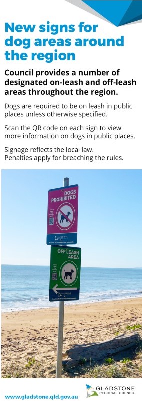
Temporary Small Dogs and Puppies Area in Webb Park, Gladstone
- Location
- Small Dogs and Puppies Area in Webb Park, Gladstone
- Description of Works
- Council has temporarily closed the Small Dogs and Puppies area in Webb Park (a dog off-leash park) on Palm Drive as we undertake maintenance work to rectify dangerous ground conditions.
- Commencing
- Friday 11 April 2025
- Completion
- May 2025
- More information
-
We appreciate your patience and co-operation while works are undertaken.
If you have any questions about these works, please contact Council on 4970 0700.
-
Turtleway Bridges - Replacement
- Location
- Stirling Park, Boyne Island and Canoe Point, Tannum Sands
- Description of Works
-
Work is scheduled for replacement of two Turtleway pedestrian bridges as part of our Capital Works program.
Removal of the existing structures and installation of new Turtleway footbridges will reduce ongoing maintenance costs and improve longevity of these valuable community assets. - Commencing
- Monday 10 February 2025
- Completion
- 30 June 2025
- More information
-
To keep our community safe, full closure of these footbridges will be needed with no pedestrian bridge access from Monday 10 February 2025 until about the end of June 2025. Pedestrian detours will be required around the work areas.
For cost savings and work efficiencies, the two Turtleway pedestrian bridges will be closed at the same time.
Works will be scheduled consecutively for bridge removal and replacement at the various sites with community and worker safety a priority.
Replacement of these footbridges will involve installation of new structures to provide improved community connectivity for years to come.
Council looks forward to delivering these asset improvement works and appreciates the patience and understanding of the community while these necessary pedestrian bridge replacements are undertaken.
Planned works forecast, weather permitting
- Mon 10 Feb to Fri 16 May: Stirling Park, Boyne Island footbridge
- Mon 7 Apr to Mon 30 Jun: Canoe Point, Tannum Sands footbridge
Work at both footbridges will involve:
- Mobilisation to site
- Create new access to site
- Removal of existing bridge, abutments and footings
- Site survey existing bridge line
- Installation of screw piles with concrete caps
- Survey footings and abutments
- Installation of new abutments with footing inspection
- Concrete curing time
- Bridge installation
- Demobilisation from site
What to expect
Please be mindful of construction works occurring:
- Noise and vibration from the work area is expected.
- Temporary fencing installed.
- Heavy machinery operating.
- Please follow directions and signage in the area.
- Pedestrian detour in place for the Stirling Park footbridge.
- Pedestrians are required to plan an alternative route to avoid the works area near the Canoe Point footbridge.
The Turtleway Bridges Replacement project is proudly funded by the Federal Government’s Local Roads and Community Infrastructure (LRCI) Program - Phase 4.
-
Vehicle access restrictions, Joey Lees beach, Curtis Island
- Location
- Curtis Island National Park and Conservation Park
- Description of Works
-
Vehicle access to the Joey Lees beach and lower sections of the headland is no longer permitted.
This closure is necessary to enable rehabilitation of eroded sections of the Joey Lees headland to protect the natural values of the coastal headland communities. - Commencing
- 1 June 2024
- Completion
- 31 May 2025
- More information
-
It is hoped that through the completion of the rehabilitation works the natural integrity of the headland will be reinstated and continue to enhance natural visitor experiences.
A new three-bay car park has been provided on the top of the headland for day visitors. Existing pedestrian access to the beach and lower sections of the headland are maintained.
Please monitor park alerts on the department's website for updated information.
This alert applies to the following park:
-
QPWS Planned Burn Castle Tower National Park - 22 April - 31 August 2025
- Location
- Castle Tower National Park
- Description of Works
- The Queensland Parks and Wildlife Service (QPWS) will be conducting planned burns within Castle Tower National Park from 22 of April 2025 – August 31st 2025, weather permitting, as part of the annual hazard reduction/conservation management program for parks and forests.
- Commencing
- 22 April 2025
- Completion
- 31 August 2025
- More information
-
These burns aim to reduce the volume of forest fuels and to create a mosaic pattern of burnt and unburnt areas. This will help reduce the intensity of any subsequent wildfires and provide favourable conditions for natural forest regeneration.
As a result, smoke may be seen in the vicinity of Castle Tower NP. Smoke can decrease visibility on the roads, so it is important that motorists drive safely to the conditions. Visitors and residents should close windows and doors and keep medications close by if suffering from a respiratory illness.
For more information, please call QPWS Agnes Water office on 0429 633 770.
Please observe all signage, barriers and directions from rangers and do not enter closed areas.
Stay up-to-date with Current bushfire warnings and incidents from Queensland Fire Department (QFD).
-
QPWS Planned Burn Eurimbula National Park - 22 April - 31 August 2025
- Location
- Eurimbula National Park
- Description of Works
- Queensland Parks and Wildlife Service (QPWS) will be conducting planned burns within Eurimbula National Park from 22 of April 2025 - August 31 2025, weather permitting, as part of the annual hazard reduction/conservation management program for parks and forests.
- Commencing
- 22 April 2025
- Completion
- 31 August 2025
- More information
-
These burns aim to reduce the volume of forest fuels and to create a mosaic pattern of burnt and unburnt areas. This will help reduce the intensity of any subsequent wildfires and provide favourable conditions for natural forest regeneration.
As a result, smoke may be seen in the vicinity of Eurimbula NP, including campgrounds and day-use areas, and within the townships of Agnes Water, Captain Creek and Turkey Beach.
Smoke can decrease visibility on the roads, so it is important that motorists drive safely to the conditions. Visitors and residents should close windows and doors and keep medications close by if suffering from a respiratory illness.
For more information, please call QPWS Agnes Water office on 0429 633 770.
Please observe all signage, barriers and directions from rangers and do not enter closed areas.
Stay up-to-date with Current bushfire warnings and incidents from Queensland Fire Department (QFD).
-
QPWS Planned Burn Deepwater National Park - 22 April - 31 August 2025
- Location
- Deepwater National Park
- Description of Works
- Queensland Parks and Wildlife Service (QPWS) will be conducting planned burns within Deepwater National Park from 22 of April 2025 – August 31st 2025, weather permitting, as part of the annual hazard reduction/conservation management program for parks and forests.
- Commencing
- 22 April 2025
- Completion
- 31 August 2025
- More information
-
These burns aim to reduce the volume of forest fuels and to create a mosaic pattern of burnt and unburnt areas. This will help reduce the intensity of any subsequent wildfires and provide favourable conditions for natural forest regeneration.
As a result, smoke may be seen in the vicinity of Deepwater NP, including campgrounds and day-use areas, and within the townships of Agnes Water and Deepwater.
Smoke can decrease visibility on the roads, so it is important that motorists drive safely to the conditions. Visitors and residents should close windows and doors and keep medications close by if suffering from a respiratory illness.
For more information, please call QPWS Agnes Water office on 0429 633 770.
Please observe all signage, barriers and directions from rangers and do not enter closed areas.
Stay up-to-date with Current bushfire warnings and incidents from Queensland Fire Department (QFD).
-
QPWS Planned Burn in Joseph Banks Conservation Park - 22 April - 31 August 2025
- Location
- Joseph Banks Conservation Park
- Description of Works
- Queensland Parks and Wildlife Service (QPWS) will be conducting planned burns within Joseph Banks Conservation Park from 22 of April 2025 – August 31st 2025, weather permitting, as part of the annual hazard reduction/conservation management program for parks and forests.
- Commencing
- 22 April 2025
- Completion
- 31 August 2025
- More information
-
These burns aim to reduce the volume of forest fuels and to create a mosaic pattern of burnt and unburnt areas. This will help reduce the intensity of any subsequent wildfires and provide favourable conditions for natural forest regeneration.
As a result, smoke may be seen in the vicinity of Joseph Banks Conservation Park, including lookouts and walking tracks, and within Seventeen Seventy.
Smoke can decrease visibility on the roads, so it is important that motorists drive safely to the conditions. Visitors and residents should close windows and doors and keep medications close by if suffering from a respiratory illness.
For more information, please call QPWS Agnes Water office on 0429 633 770.
Please observe all signage, barriers and directions from rangers and do not enter closed areas.
Stay up-to-date with Current bushfire warnings and incidents from Queensland Fire Department (QFD).
# | Name | Size |
---|
Archived public notices
# | Name | Size |
---|
# | Name | Size |
---|
# | Name | Size |
---|
# | Name | Size |
---|
# | Name | Size |
---|
# | Name | Size |
---|
Roadworks, conditions and closures
Refer to the RegionWatch website for up to date road conditions and scheduled works. Information and updates are posted on our Facebook page for short term and unscheduled works.
Regular maintenance and operational development of Gladstone Region roads are conducted by Council staff throughout the year.
For more information, please contact Council on (07) 4970 0700.
-
Refer to RegionWatch for current road conditions
-
Asphalt Resurfacing - Gladstone
- Location
- Stage 1 - Sections of J Hickey Avenue, Tinaroo Court, Fairbairn Place. Stage 2 - J Hickey Av (Mcginlay St to Gretel Dr)
- Description of Works
-
Stage 1 and 2 of our resurfacing program, scheduled as part of Council’s 2024/25 Capital Works program, includes pavement repairs and asphalt renewals along about 2.7km of J Hickey Avenue, in addition to side streets Tinaroo
Court and Fairbairn Place, delivering over 43,520m2 of new road surfacing and line marking for the community.
Removing defects in the roadway and overlaying the road with a new asphalt surface will extend their life and provide a smoother driving surface. - Commencing
- Monday, 24 February 2025
- Completion
- Thursday, 1 May 2025
-
The Contractor will letterbox drop properties within the works area prior to works.
Planned Works, weather permitting
22 Apr-1 May: Stage 2 works (Line-marking near Col Brown end)
Above dates are a guide only. Due to the nature of construction projects and unforeseen delays, works may vary.
What to expect
- Works generally carried out from Mon-Fri, 6am-6pm.
- Residents asked to park their vehicles off the road when works are planned in their street.
- Noise, dust and vibration may be generated from construction activities.
- At times, some traffic delays and some restricted access to streets.
- Traffic management in place.
- Access to properties maintained.
- Contractors to help direct drivers entering/exiting properties.
- Please drive carefully through work areas and adhere to any changed road conditions and reduced 40km/h speed limits.
Overall road resurfacing works in Gladstone are included in Council’s annual road renewal budget.
J Hickey Avenue asphalt resurfacing works are proudly supported by the Australian Government’s Local Roads and Community Infrastructure (LRCI) Program - Phase 4.
-
End of Parksville Drive to Kahler Close - New Footpath
- Location
- Parksville Drive to Kahler Close, Kirkwood
- Description of Works
-
Work to construct a new footpath connecting the end of Parksville Drive to Kahler Close, Kirkwood is anticipated to start in about July.
This project will involve construction of about 80m of new pathway and is included in Council’s 2024/25 Capital Works program.
In the lead up to footpath construction, surveys have been underway in the area and site preparations will start soon. - Commencing
- 1 July 2025
- Completion
- 31 August 2025
-
The new pathway will connect to existing footpath in the area, provide greater pedestrian connectivity for the community and improve pedestrian safety to the Kirkwood shopping centre.
This project supports Council’s Pedestrian and Cycle Strategy, providing cyclists and pedestrians with a safe and dedicated pathway, reducing the need to share the roadway with motorists.
Planned Works
Site preparation works will start soon.- Two trees on the footpath alignment have been condition assessed and identified for removal in coming weeks.
- Council takes a sensitive approach to remove trees only where absolutely necessary to enable works and to ensure the safety of workers and community.
- More trees will be planted as part of landscape works towards completion of footpath construction.
- Overall path construction works: Anticipated to start from about July for about six weeks, weather permitting.
- In March: Targeted tree removal, electrical works including installation of electrical conduit, light pole footings.
- From about July: Construction of new footpath, installation of kerb ramps, bollards, signage.
Please use this information as a guide only. Due to the nature of construction projects and unforeseen delays, works may vary.
What to expect
To keep our community safe and to minimise disruptions:- Work will occur in stages, commencing with tree removal in the next two weeks followed by the electrical works, weather permitting.
- Works will take place Monday to Friday, 6am-6pm.
- Machinery noise, vibration and dust can be expected from the project site.
- At times, some pedestrian and traffic disruptions.
- Please follow signs and directions.
The end of Parksville Drive to Kahler Close Construct Shared Path project is proudly supported by the Queensland Government’s Cycle Network Local Government Grants Program and Gladstone Regional Council.
-
Jeffery Court - Road Safety Improvements
- Location
- Jeffery Court, Agnes Water
- Description of Works
-
Council is undertaking road safety improvement work along a section of Jeffery Court adjacent to Tom Jeffery Memorial Park, Agnes Water.
Following community feedback and review of this busy traffic area, consideration has been given to public safety, speed limit and improvements to traffic flow to increase safety for our community and visitors to the region.
Work will be completed in stages as part of Council’s 2024/25 Capital Works program to complement later construction of the nearby Agnes Water Beach Visitor Carpark. - Commencing
- 21 October 2024 (Stage 1). Further work dates for Stage 1 completion and Stage 2 works to be advised.
- Completion
- Dates to be advised.
-
Project update
- Majority of Stage 1 roadworks are complete with a portion of remaining works to be delivered.
Work is scheduled, site conditions and weather permitting, along the northern side of Jeffery Court (on the road and embankment near the boundary of NRMA Agnes Water Holiday Park and Tom Jeffery Memorial Park):
- Stage 1 - Drainage, road widening, new kerb, asphalt reseal, line-marking and road sign installation within the work area. Installation of mountable kerbing.
- Stage 2 - Construction of retaining wall and boardwalk on embankment adjacent to Tom Jeffery Memorial Park.
More information
To make it safer for drivers, pedestrians, community and visitors to the park and beach, when complete, works along this section of Jeffery Court will introduce:
- Reverse angle parking: 18 parking bays to replace existing parallel parking bays, utilising available space and providing greater off-road safety during vehicle unpacking/loading.
- Lower speed limit: a 10km/hr shared zone will apply.
- No queue signage: traffic will not be permitted to queue on the road.
- Existing one-way traffic flow to remain: current one-way flow of traffic conditions will continue.
- Retaining wall and boardwalk: Work in 2025 to provide a safe pedestrian path to connect to existing pathways.
What to expect during works
During works, you’ll notice workers and activity in the work area with some brief traffic disruption and partial road closure required at times.- Works - Monday to Friday, 7am-5pm, site conditions and weather permitting.
- Traffic management.
- At times, dust and machinery/equipment noise can be expected from the project site.
- Some local traffic only restrictions under traffic control.
- Reduced speed limit.
- At times, partial road closure and road changes.
- Please follow signs and directions.
-
Lowmead Road - Upgrade Work
- Location
- Staged works along Lowmead Road from the Fingerboard Rd-Lowmead Rd intersection to the town of Lowmead
- Description of Works
-
The Lowmead Road Safety and Sealing Upgrade project consists of four stages of road upgrades forecast to be completed on Lowmead Road during this financial year and the next.
Sections of road will be upgraded from the Fingerboard Road-Lowmead Road intersection to the town of Lowmead.
This project will provide an improved, more resilient road with alignment adjustments to offer increased safety for motorists and improved road resilience during wet weather. - Commencing
- 7 August 2023
- Completion
- Financial year 2024/25
-
What’s been happening?
ROAD CUT AT GRANITE CREEK BRIDGE - CLOSED TO ALL TRAFFIC - UNTIL FURTHER NOTICE
UPDATE @ 22 APRIL 2025
- Following significant rainfall and water inundation in the area, Lowmead Road remains cut at the Granite Creek crossing with a full closure in place to all traffic.
- Site inspections and damage assessments at the site are continuing.
- Road closed barriers are in place with the causeway closed to all traffic. Local access is not permitted.
- The working area that has been developed in Granite Creek to support bridge construction is an active worksite. Public access is not permitted. Please observe all construction signage and barriers that are in place to protect our community from construction site hazards.
- While the road remains closed to all traffic, a diversion around the area is needed. Please continue to drive safely, to conditions, and plan extra time for travel.
- Early inspections indicate that to rebuild the causeway road to a limited condition, capable of withstanding one-way traffic, substantial civil works and time would be required.
- The normal creek flows are too high, and the banks are too steep, to allow for any local access/side track to be considered.
- Our officers are working diligently, various options are currently being outworked and a number of our teams are focussed on delivering the best possible outcome for the community.
- We appreciate your patience and understanding while we work to determine the next steps for our road network in this area.
- Granite Creek Bridge
- Bridge construction works, including minor road adjustments to align road approaches with the new bridge.
- Stages 2, 3 and 4 of Lowmead Road
- Local road users will have noticed approximately 2000m of sealing works completed in Stage #3, in a stretch of road between Colosseum Creek and Granite Creek.
Planned works, site conditions and weather permitting:
- Stage #2
- Stage #2 is approximately a 7km of section of road that commences at Colosseum Creek crossing and continues towards Lowmead. Construction works commenced in August 2024 and are anticipated to continue until about Easter 2025.
- While project works are underway, Lowmead Road is open to local traffic only, specifically for access to homes and properties. All residents who must use the road are asked to slow down, drive to conditions, observe warning signs and reduced speed zones.
- Stage #3, Stage #4
- Council has a Contractor team working on these sections of road, which are separated by Granite Creek. The Contractor team is also completing the Granite Creek Bridge works.
- Road conditions to expect
- Suburb: Lowmead Road to Mount Tom
- Street: Lowmead Road from Clarkes Road to Fingerboard Road
- What’s happening:
- Road works. Closed. Local traffic only.
- Detour for non-local traffic via Gorge Road, Lowmead Road or Tablelands Road, Berajondo.
- Expect delays. Follow signs and directions.
More information
- All forecast works in 2025 will occur either on or directly adjacent to the existing road. Traffic controls will be in place, so please observe directions and reduced speed zones at all times.
- Local road users should anticipate significant site activity while multiple crews (both Council and Contractors) will be working simultaneously across Stages 2, 3 and 4 and the Granite Creek Bridge site.
- Noise, dust, construction traffic and heavy machinery is expected in the area.
The Lowmead Road Safety and Sealing Upgrade project is being delivered by Council and its Contractors in 2024 and is included in Council’s Capital Works program. This project has secured the support of the Federal Government to widen and seal more than 20km of Lowmead Road in 2024 via the Remote Roads Upgrade Pilot Program (RRUPP). The Granite Creek Bridge project has secured funding from Disaster Recovery Funding Arrangements (DRFA), which joins Commonwealth and State government funding to help communities recover from disasters.
-
Matthew Flinders (Marina) Bridge on Bryan Jordan Drive closure for essential maintenance
- Location
- Matthew Flinders (Marina) Bridge
- Description of Works
- Council wishes to advise that the Matthew Flinders (Marina) Bridge on Bryan Jordan Drive will be closed for planned maintenance.
- Commencing
- 7am Wednesday 7 May 2025
- Completion
- 3pm Wednesday 7 May 2025
-
During this period, the bridge will be closed to all vehicles and unavailable for watercraft requiring a bridge lift.
We appreciate your patience and understanding while these essential works are carried out.
Please contact Water Mechanical-Electrical Team on 4970 0700 regarding any issues or concerns.
-
Rocky Crossing Road - Roadworks
- Location
- Rocky Crossing Road, Round Hill
- Description of Works
- These works are included in Council’s 2024/25 Capital Works program and will involve widening, rehabilitation of the road and resealing. All works will occur on the current road alignment.
- Commencing
- Mid-March 2025
- Completion
- 31 July 2025
-
Planned Works
Works are anticipated to occur from mid-March to July, site conditions and weather permitting.- From mid-March: Residents and business owners in the area can expect traffic control to be established on-site. Access will be maintained, with some brief interruptions to driveway access. Impacted residents and business owners can anticipate direct contact from Council construction personnel before any works that will affect current driveways.
- Easter stand-down period: No works are forecast during the period Friday 18 April (Good Friday) to Monday 5 May (Labor Day) inclusive.
Please use this information as a guide only. Due to the nature of construction projects and unforeseen delays, works may vary.
What to expect
Please be mindful of construction works occurring:
- Work will be carried out Monday to Friday from 6.30am to 4.30pm.
- Noise, vibration and dust from the work area is expected.
- Heavy machinery and equipment operating. Machines and equipment will be used to remove the current road surface, rehabilitate the road and to reseal the surface.
- Traffic management at times, including traffic disruptions and possible access/exit restrictions.
- Pedestrian access restrictions.
- Please follow directions and signage in the area.
The Rocky Crossing Road, Round Hill project is proudly funded by the Australian Government’s Roads to Recovery 2024-25 program.
-
Speed limit change – Anderson Way, Agnes Water
- Location
- Anderson Way, Agnes Water
- Description of Works
- Council advises that its Speed Management Committee (SMC) has approved a speed limit change on Anderson Way, Agnes Water at its meeting on 14 November 2024. The speed limit will be reduced from 80km/h to 70km/h.
-
The SMC includes representatives from Queensland Police, Department of Transport and Main Roads, and Gladstone Regional Council.
Council will commence work soon to implement this speed change by installing new speed limit signs.
If you have any enquiries or concerns, please contact Council on (07) 4970 0700.
-
Turkey Beach Road Upgrades
- Location
- Turkey Beach Road, Turkey Beach
- Description of Works
-
Road realignment upgrade and safety improvement works including road widening and road resealing.
Works Area #1 - Between Dyckhoffs Road and Scrubby Creek
Works Area #2 - Between Scrubby Creek and Sandy Creek
During construction works please plan for possible delays, speed reductions and traffic control measures.
Traffic reduced to single lane, as required.
Motorists are urged to drive carefully through the works area and adhere to any reduced speed limits, changed traffic conditions or directions. - Commencing
- Late May 2024
- Completion
- Mid 2025
-
Turkey Beach Road Safety Improvement works are proudly funded by the Queensland Government through the Transport Infrastructure Development Scheme (TIDS) and Gladstone Regional Council.
Water & Sewer interruptions
Refer to the RegionWatch website for up to date interruptions and scheduled works.
Regular maintenance and operational development of Gladstone Region water and sewer networks are conducted by Council staff throughout the year.
For more information, please contact Council on (07) 4970 0700.
After water is turned on:
- On resumption of the water supply a hot water tap should be turned on to flush any air pockets from the pipes, then turn the hot water heater on again.
- We advise that you check the water prior to use. If it appears discoloured we suggest you turn on the nearest external tap to the meter and let it run for a period of time, or until it runs clear, and then do the same to the furthest external tap from the meter, to clear your pipework.
- Please do not wash clothes at this time to prevent staining from any discoloured water.
Council apologises for any inconvenience this interruption may cause. For more information contact us online or call on (07) 4970 0700.
-
Sewer Main Renewal
- Location
- Several locations across Gladstone, Boyne Island, Tannum Sands and Calliope
- Description of Works
-
Sewer main renewal works will occur in stages in various locations across the region.
Works are part of a multi-year Capital Works project to renew sewer main assets in areas of Boyne Island, Calliope, Gladstone and Tannum Sands to improve network reliability, operational efficiency and reduce ongoing maintenance costs. - Commencing
- Monday 28 April 2025 (Stage 1)
- Completion
- Friday 10 October 2025 (Stage 1)
- More information
-
This project will involve sewer cleaning, relining and junction sealing.
Sewer services are not expected to be affected by these renewal works however this method of pipeline rehabilitation may produce minor noise disturbances, additional traffic, and possibly odour for short periods.
Access to properties will only be required when entry is necessary to access Council’s sewer main assets, complete the works, or for service junction repair and connection to the new sewer pipe. Entry to properties will be made in accordance with Part 2, Section 144 of Local Government Act 2009.
Planned Works, weather permitting
- Program of works information will be provided here when finalised.
Above dates are a guide only. Due to the nature of construction projects and unforeseen delays, works may vary.
What to expect
- Works between 6.30am to 6.30pm, Monday to Friday and 6.30am to 5pm on Saturday, weather permitting.
- Council Contractors will carry identification.
- Access if required only to external areas of property, including backyards.
- Please ensure clear access to any sewer main access points on your property.
Residents will receive further access notification from the Contractor closer to works. Please relocate/restrain any animals and enable access through any gates during this timeframe.
- Program of works information will be provided here when finalised.
-
Unplanned Maintenance - Agnes Water Waste Water Treatment Plant
- Location
- Agnes Water
- Description of Works
- Due to maintenance work at the Trade Waste/Septage receival station at Agnes Water WWTP. All liquid waste disposal at this location is directed to Gladstone Waste Water Treatment Plant, 17 Albert Road, Callemondah.
- Commencing
- Friday 26 July, 2024
-
Sewer Manhole Renewal
- Location
- Various areas in Calliope, Boyne Island and Gladstone
- Description of Works
-
Sewer Manhole Renewal work is being delivered in stages across Gladstone and involves rehabilitation works to improve reliability of the sewer network, reduce ongoing maintenance costs and meet wastewater sustainability objectives.
Machinery operation, vehicle movements, odour and noise will be associated with this work. Sewer services are not expected to be affected. - Commencing
- Monday 28 April 2025
- Completion
- Friday 27 June 2025
- More information
-
Several assets have been identified as requiring upgrade or repair to prevent water infiltration into the sewer network.
Works are part of Council’s continuous focus on infrastructure improvements and will involve relining or refurbishment works of sewer manholes in areas of Calliope, Boyne Island and Gladstone.
This project follows routine inspection of sewer manholes throughout the region and the development of a prioritised works program.
Access to properties will only be required when entry is necessary to access Council’s sewer main assets, complete the works, or for service junction repair and connection to the new sewer pipe. Entry to properties will be made in accordance with Part 2, Section 144 of Local Government Act 2009.
Planned Works, weather permitting
- Gladstone (along Chapple St, Toolooa St, Leo Zussino Dr and Kirkwood Rd)
- Boyne Island (along Bluewater Dr and Jacaranda Dr)
- Calliope (along Dawson Highway and Sun Court)
Above dates are a guide only. Due to the nature of construction projects and unforeseen delays, works may vary.
What to expect
- Works between 6.30am to 6.30pm, Monday to Friday and 6.30am to 5pm on Saturday, weather permitting. Some night works may be required if determined by operational requirements.
- Council Contractors will carry identification.
- Access if required only to external areas of property, including backyards.
- Please ensure clear access to any sewer main access points on your property.
Residents will receive further access notification from the Contractor closer to works. Please relocate/restrain any animals and enable access through any gates during this timeframe.
-
Seventeen Seventy Sewer Rising Main Replacement
- Location
- Captain Cook Drive, Seventeen Seventy
- Description of Works
-
Works to relocate and replace 1000m of existing sewer rising main along the coastline adjacent to Captain Cook Drive at Seventeen Seventy will occur from early December 2024 to June 2025, site conditions and weather permitting.
Works will start near Endeavour Park and finish near the Seventeen Seventy boat ramp.
New alignment of the sewer rising main will prevent risks of uncontrolled sewer release to the immediate environment, supporting objectives of Council’s Our Coast Our Future Coastal Hazard Adaption Strategy to ensure appropriate adaptation responses to help avoid, mitigate, and manage the risk of coastal hazards.
This project is included in Council’s Capital Works program. - Commencing
- Late November 2024
- Completion
- June 2025
- More information
-
Work will generally involve:
- Removal and/or grouting capping of existing redundant sewer rising main (located within the foreshore area),
- Installation of new sewer rising main within the road reserve,
- New sewer rising main connection to the existing network,
- Testing and commissioning of the new sewer rising main.
Planned works forecast, site conditions and weather permitting
- Late February to mid-April: Captain Cook Drive, starting at Air Sea Rescue Park and finishing about 150m from boat ramp
- March to June: Pump station works
- Mid-April to June: Captain Cook Drive road rectification and sealing
Saturday Works: Saturday 5 April to Saturday 26 April, from 7am to 3pm
- Council’s Contractor will continue Saturday works throughout April to continue finalisation of civil works, continue the good progress being made and mitigate any rain delays to ensure the Sewer Rising main is installed within the scheduled timeframe for works.
- During construction works, there will be on-site traffic control in line with the existing single lane traffic used in other stages of the project.
- Throughout the day, there may be periods of disruption for residents accessing or exiting their properties, as well as for traffic along Captain Cook Drive, however this will be minimised.
Please use this information as a guide only. Due to the nature of construction projects and unforeseen delays, works may vary.
What to expect
Work is being planned in stages with public safety as a priority and with consideration of peak holiday times, the community and visitors to our region.
When works are underway in 2025:
- Contractors in the area on weekdays with at times, work at night and on weekends.
- Equipment and machinery operating with noise and dust likely from the project area.
- At times, some pedestrian detours, disruption to traffic flow, single lane alternating traffic and parking restrictions within the work area.
- At times, some amenities near the immediate work area will be closed for public safety.
- Please follow signs and directions and plan for road and pedestrian changes near the works area.
The Seventeen Seventy Sewer Rising Main Replacement project is funded by the Queensland Government’s QCoast2100 program and Gladstone Regional Council.
-
Tannum Sands Sewer Rising Main Replacement
- Location
- Millennium Esplanade, Tannum Sands from the northern end to just south of the Surf Lifesaving Club
- Description of Works
-
Works to upgrade the sewer rising main will occur until June 2025, site conditions and weather permitting.
The existing 370m long sewer rising main pipeline, constructed in 1976, is located along the eastern side of Millennium Esplanade, Tannum Sands.
This asset has been condition assessed and identified as being at the end of its service-life and needing replacement. This project is included in Council’s 2024/25 Capital Works program with work to be carried out by a Contractor.
- Commencing
- Late January 2025
- Completion
- June 2025
- More information
-
Work will involve:
- Removal and/or grouting of existing redundant sewer rising main (located under road and footpaths in some areas),
- Installation of new sewer rising main,
- New sewer rising main connection to the existing network,
- Testing and commissioning of the new sewer rising main.
What to expect- Equipment and machinery operating in the area, noise and dust likely from the project area.
- A temporary on-site work area has been established at the northern end of Millennium Esplanade.
- At times, some pedestrian detours, disruption to traffic flow, and parking restrictions will be experienced along the esplanade.
- Work is planned to occur in stages to help minimise public disruptions.
- To keep the public safe, there may be times when some amenities near the immediate work area may also need to be closed.
Planned worksProject works are continuing along Millennium Esplanade.
- Through traffic restored from Beach Avenue towards the Tannum Sands Surf Life Saving Club.
- Works underway (Stage 4) on the main sewer pit and gravity sewer main at the top, northern end of Millennium Esplanade. (see map below)
- Works are also occurring in the Stage 1 area near the toilet block towards the southern end of the esplanade. (area highlighted at bottom of map)
- Detours around work areas but pedestrian access remains to:
- the beach,
- Tannum Sands Surf Life Saving Club Café, Bar & Bistro,
- playground,
- majority of the esplanade.
- Carparks remain accessible, but with some parking restrictions.
- If in the area, please follow signs and directions.
Yellow areas highlight current work areas
-
Advanced Water Meters - Stage 3 Installation
- Location
- Clinton, Calliope, Mount Larcom and parts of Kirkwood
- Description of Works
-
Upgrade of existing water meter infrastructure to new, advanced water meter infrastructure at residential and commercial properties in Clinton, Calliope, Mount Larcom and parts of Kirkwood.
These works are Stage 3 of a whole-of-region, multi-year Capital Works project to upgrade existing water meter infrastructure to new, advanced water meter infrastructure. - Commencing
- February 2025
- Completion
- 30 June 2025
- More information
-
The installation of advanced water meters and access to associated technology will provide significant benefits to residential households and businesses by:
- Enabling early detection of leaks.
- Providing data and information online so the user can review and manage their water usage.
- Enabling Council officers to respond more effectively to usage enquiries regarding connections.
Every property in Clinton, Calliope, Mount Larcom and some properties within Kirkwood with an existing water meter will have upgraded infrastructure installed between February and June 2025, between 7am and 5pm Monday to Friday, with weekend work (involving later start times) approved by Council.
The age of a property’s existing water meter will determine if it is fully replaced as part of the upgrade, or if the existing asset can be retained and an advanced water meter infrastructure sensor added. There is no cost to property owners associated with this upgrade.
What to expect during works
- Council Contractors, Taggle Systems, will carry identification with them.
- Water meter upgrade takes about 15 minutes depending on the complexity of your meter.
- A vacuum truck may be required at some sites. If this is the case, please expect some noise.
- Water will be disconnected during works, stopping water flow for the installation period.
- If water is flowing through the meter and we are unable to make contact, we will come back at a later stage.
- A calling card will be left in your letterbox/on your property to advise if the installation was complete or if you need to contact Council to arrange a time for installation completion.
If you have animals or locked gates and need to be present at the install, or if you have any questions about this project, please contact Council on 4970 0700 or visit your local Council office at Mount Larcom, Calliope or Gladstone.
Following installation, residents can sign up to the My Water portal which will show near real-time water usage. Users can set up high usage alerts and receive monthly water usage reports by email.
Living Here
- Pets and Animals
- Residents
- Report
- Environment
- BackEnvironment
- Air Quality
- Biodiversity
- Biosecurity
- Blue-green algae blooms
- Bushfire Mitigation
- Coasts and Coastal Vegetation
- CoastSnap
- Conservation Programs and Initiatives
- Erosion and Sediment Control
- Feral Animals
- First Nations Fire and Land Officer
- Landfill Gas Abatement
- Mosquitoes
- Pests and Weeds
- Weed Spray Equipment Hire
- Wildlife
- Community Development
- Community Investment
- Services
- Emergencies

Latest CONNECT News out now
More Information
The cookbook is a collaborative effort between Gladstone Regional Council and Gladstone Region Neighbourhood Centre, proudly presented as part of Welcoming Week celebrations.
Download the cookbookGladstone Regional Council
Connect. Innovate. Diversify.
Get in Touch
Phone
(07) 4970 0700
Opening Hours
8.30am - 5pm Monday to Friday
Social media
Postal Address
PO Box 29, Gladstone Qld 4680
Council Offices
101 Goondoon Street, Gladstone Qld 4680
3 Don Cameron Drive, Calliope Qld 4680
41 Blomfield Street, Miriam Vale Qld 4677
Cnr Wyndham & Hayes Avenues, Boyne Island Qld 4680
Rural Transaction Centres
71 Springs Road, Agnes Water Qld 4677
47 Raglan Street, Mount Larcom Qld 4695
Footer Acknowledgement
Gladstone Regional Council would like to acknowledge the Bailai, the Gurang, the Gooreng Gooreng and the Taribelang Bunda people who are the traditional custodians of this land. Gladstone Regional Council would also like to pay respect to Elders both past, present and emerging, and extend that respect to other Aboriginal and Torres Strait Islander people. Learn more about Council's Reconciliation Action Plan (RAP).
Chat Popup
All content © Gladstone Regional Council. All Rights Reserved.
Back to the top